

 © Steve Vaughn/Panoramic Images (Florida Title Image Large)
Under-Protected Natural Communities
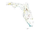
The Under-protected Natural Communities data layer shows the statewide distribution of 12 natural communities needing additional protection in Florida, including upland glade, pine rockland, rockland hammock, scrub, dry prairie, seepage slope, sandhill, sandhill upland lake, coastal uplands, upland hardwood forest, pine flatwoods, and coastal wetlands (mangrove and salt marsh).
This data layer was created by FNAI as part of the Florida Forever Conservation Needs Assessment, a statewide analysis of natural resource conservation priorities for the Florida Forever statewide environmental land acquisition program. Under-protected communities include those that are under-represented on conservation lands as well as fragile coastal resources.
Depending on the classification system followed, Florida features as many as 81 different natural community types (FNAI 1990). Many of these community types, particularly wetland communities, are relatively well represented on existing conservation lands, and therefore are less of a priority for land acquisition than some of Florida's rarest communities that are currently not well-protected.
Based on Florida Department of Environmental Protection criteria, a natural community is considered to be inadequately represented on conservation lands if less than 15% of the original extent of that community is currently found on existing conservation lands. Coastal uplands, which include beach dune, coastal grassland, coastal strand, and maritime hammock, and coastal wetlands, which include mangrove and salt marsh, were mapped because these communities are considered fragile coastal resources, a priority of the Florida Forever program.
The natural communities were mapped based on a combination of field observations, remotely sensed vegetation data (FWC satellite imagery landcover) and aerial photography (classed into FLUCCS codes by Florida’s Water Management Districts).
More Information
Relevance to LandScope:
The Under-protected Natural Communities is a primary biodiversity data layer used for statewide and regional conservation planning in Florida. It informs the priorities of the Florida Forever, and the Critical Lands and Waters Identification Project (CLIP). This data layer indicates the likely presence of rare or declining natural communities based primarily on remotely-sensed data.
How to get more information:
For a detailed description of methods, please refer to: Conservation Needs Assessment Technical Report
Available at FNAI's Florida Forever page
For an overview of the Florida Forever Conservation Needs Assessment, please refer to: Conservation Needs Assessment Summary Report – December 2000
Available at FNAI's Florida Forever page
How to get the data layer:
To obtain this data, visit the Century Commission website.
Go to the Map

Use the interactive map to zoom smoothly from a national view to state and local perspectives anywhere across the country.

