

 © Steve Vaughn/Panoramic Images (Florida Title Image Large)
Aggregated CLIP Priorities
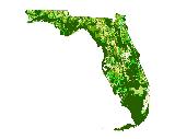
The Aggregated Critical Lands and Waters Identification Project (CLIP) Priorities depict areas of opportunity for protecting biodiversity, landscapes, and water resources across the state. Developed by the Florida Natural Areas Inventory, the University of Florida, and the Florida Fish and Wildlife Conservation Commission, CLIP is intended to provide a broad synthesis of natural resource GIS data to support comprehensive identification of statewide conservation opportunities.
The best available GIS data are combined in a hierarchical system that includes core data layers, resource categories, and aggregated CLIP priorities. Developed with the consensus of a Technical Advisory Group, the aggregated CLIP priorities layer highlights the conservation significance of protecting biodiversity, landscape attributes, and high quality surface water resources at a statewide scale.
More Information
Relevance to LandScope:
The Aggregated CLIP Priorities may be used as an informative support and decision-making tool for the Century Commission and the Florida Fish and Wildlife Conservation Commission Cooperative Conservation Blueprint, and as a resource planning guide for state, regional, and local entities interested in effective natural resource protection and management. Instead of focusing on particular resources, CLIP provides a broad synthesis of natural resource GIS data to support comprehensive identification of statewide conservation opportunities.
How to get more information:
CLIP Phase I Report and Report on the Completion of the CLIP Database Version 1.0 is available online
How to get the data layer:
To obtain this data, visit the Century Commission website
Go to the Map

Use the interactive map to zoom smoothly from a national view to state and local perspectives anywhere across the country.

