

About LandScope
LandScope America is an online resource for the land-protection community and the public. Developed in collaboration by NatureServe, the National Geographic Society, and many partner organizations, LandScope America is designed to increase the pace and effectiveness of conservation action and investment throughout the United States.
-
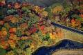
© BRUCE DALE (Project Overview Featured Image)
LandScope Overview
Combining the best available conservation science and information technology with multi-media storytelling, LandScope America is the conservation guide to America's natural places.
-
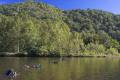
© Jack Looney (Thanks to Our Partners Featured Image)
Thanks to Our Partners
LandScope America relies on the voluntary participation of an incredible group of partners. We thank everyone on this growing list.
-

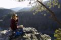
© LYNN JOHNSON (How You Can Participate Featured Image)
How You Can Participate
LandScope America is an evolving and ongoing project, and we enthusiastically invite your participation. Here are a few ways you can join the effort.
-

© Shutterstock (Plan Conservation Projects Featured Image)
Conservation Projects
Using LandScope, you can map and track on-the-ground conservation projects and actions.
-
© Jack Looney (About the Data Guidelines Featured Image)
About the Data
Dozens of groups are already contributing data about conservation issues to LandScope, and we welcome further data contributions as we continue to expand the website. Find out what spatial data is available, how to contribute data, and guidelines for data use.
-
© Matt Ragen/Shutterstock (Newsroom Featured Image)
-
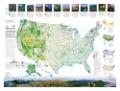
Conservation Map of the U.S.
This compelling new map, produced by the National Geographic Society and NatureServe, tells the story of the changing face of land conservation in the United States. View the map in detail and find out how to order your own copy.
-
© Steve Maehl/Shutterstock (Team Blog Featured Image)
LandScope Team Blog
Our team blog will give you a behind-the-scenes look at how the project is going. Be sure to subscribe to the RSS feed to receive new entries automatically.
-

© Shutterstock (Frequently Asked Questions Featured Image)
Frequently Asked Questions
Find answers to the most frequently asked questions about LandScope America.