

 © Steve Vaughn/Panoramic Images (Florida Title Image Large)
Critical Lands and Waters Identification Project (CLIP)
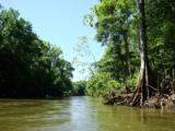
© FNAI Critical Lands and Waters Identification Project (CLIP) image
The Critical Lands and Waters Identification Project (CLIP) is a database that identifies lands and waters with important natural resource attributes of state and regional significance. The CLIP Database can serve as an informative statewide support and decision-making tool for identifying important opportunities to protect Florida's essential ecosystems.
The Florida Natural Areas Inventory, the University of Florida, and the Florida Fish and Wildlife Conservation Commission have developed the CLIP Database to assess and incorporate available GIS data for identifying statewide areas of interest for protecting biodiversity, water resources, ecosystem services, and other natural resource values. The available data were collected and assessed with the help of a team of advisors, collectively called the Technical Advisory Group (TAG). The best available data were then combined in a hierarchical system including core data layers, resource categories, and aggregated CLIP priorities. The Florida Forever Conservation Needs Assessment is the foundation for many of the CLIP datasets.
CLIP may be used as a decision-making support tool for informing the work of the Century Commission and the Florida Fish and Wildlife Conservation Commission Cooperative Conservation Blueprint. The data layers may also be suitable as a resource-planning guide for various state, regional, and local entities interested in effective natural resource protection and management. Whereas other planning efforts have focused on particular resources, CLIP provides a broad synthesis of natural resource GIS data to support comprehensive identification of statewide conservation opportunities. CLIP offers a transparent incorporation and prioritization of available data, a credible process using well-documented data based on expert consensus, and the flexibility to incorporate new data as it becomes available in order to develop enhanced identification of natural resource conservation opportunities. Ultimately, CLIP represents a set of data tools to inform decision makers, rather than a single map or conservation plan.
Several of the CLIP data layers are described on the Conservation Priorities Data page and may be viewed on the LandScope map viewer.
More Information
Relevance to LandScope:
CLIP may be used as a decision-making support tool for informing the work of the Century Commission and the Florida Fish and Wildlife Conservation Commission Cooperative Conservation Blueprint. The data layers may also be suitable as a resource-planning guide for various state, regional, and local entities interested in effective natural resource protection and management. Whereas other planning efforts have focused on particular resources, CLIP provides a broad synthesis of natural resource GIS data to support comprehensive identification of statewide conservation opportunities. CLIP offers a transparent incorporation and prioritization of available data, a credible process using well-documented data based on expert consensus, and the flexibility to incorporate new data as it becomes available in order to develop enhanced identification of natural resource conservation opportunities. Ultimately, CLIP represents a set of data tools to inform decision makers, rather than a single map or conservation plan.
How to get more information:
The CLIP Phase I Report and the Report on the Completion of the CLIP Database Version 1.0 is available online.
Go Straight to Your State
Learn about conservation and open space in your state.

