

 © Pete Saloutos/Panoramic Images (Washington Title Image Large)
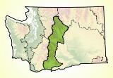
East Cascades ecoregion
On the dry side of the Cascades lies one of Washington’s most diverse ecoregions, rich in biological wealth from its montane crest down through open stands of ponderosa pine and Garry oak to the edge of the sagebrush steppe.
Location
The East Cascades ecoregion includes the mountains that lie east of the Cascade crest and the foothills as they flatten into the Columbia Plateau. In Washington, it stretches from roughly Lake Chelan in the north to the Columbia River Gorge in the south. About 10% of the state is found in the ecoregion.
Crossing the Columbia River, the mountainous ecoregion continues south through the length of Oregon.
Roads cross the East Cascades at five points. Through the northern end, Highway 2 connects the Puget Trough with towns like Leavenworth and Wenatchee. Further south, Interstate 90 crosses the Cascades, passing near Roslyn and Cle Elum.
Highway 410 and Highway 12 cross the range and continue west through Mount Rainier National Park. On the southern edge, Highway 14 follows the Columbia River through the towns of Bingen and White Salmon.
For details of this ecoregion within Washington, click a subheading in the left column.
View the more general description of this ecoregion in North America
Go to the Map

Use the interactive map to zoom smoothly from a national view to state and local perspectives anywhere across the country.