

 © Pete Saloutos/Panoramic Images (Washington Title Image Large)
Columbia Plateau ecoregion
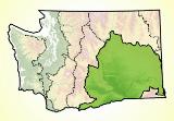
Two great rivers, the Columbia and the Snake, dominate the dramatic dry landscape of Washington’s largest ecoregion—home to an inland sea of sagebrush and the state’s fertile agricultural heartland.
Location
Lying between the Cascades and the Rockies, the semi-arid Columbia Plateau occupies nearly one-third of the state.
It is a region bordered by the Cascades to the west, the Okanogan Highlands to the north, the Rockies to the east, and the Blue Mountains to the southeast.
In Washington, the ecoregion is bisected by the Columbia River itself. The plateau that makes up this ecoregion tilts upward and southward into the Great Basin of eastern Oregon, western Idaho, and northern Nevada.
Interstate Highway 90 runs east-west through the Columbia Plateau cities of Spokane, Moses Lake, and Ellensburg. Southeast from Ellensburg, Interstate Highway 82 runs the length of the Yakima River Valley, linking Yakima with the Tri-Cities (Kennewick, Pasco, and Richland). Further north, U.S. Route 2 connects Wenatchee with the former railroad towns of Coulee City, Wilbur, and Davenport, as well as Spokane. Southward, Pullman lies close to the Idaho border, in the rolling hills of the Palouse.
For details of this ecoregion within Washington, click a subheading in the left column.
View the more general description of this ecoregion in North America
Go to the Map

Use the interactive map to zoom smoothly from a national view to state and local perspectives anywhere across the country.