

 © Pete Saloutos/Panoramic Images (Washington Title Image Large)
Okanogan ecoregion
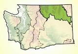
In north-central Washington, the Cascades, the Rockies, and the Columbia Plateau converge to form the Okanogan ecoregion, which boasts highland landscapes and lowland waterways, grizzly bears and sage grouse.
Location
The Okanogan ecoregion could be called the mountains between mountains—the broad highland area separating the North Cascades and the Northern Rockies.
In Washington, the ecoregion covers about 14% of the state. It extends significantly into the sage-steppe country of south-central British Columbia.
Scenic river valleys, like the Methow, the Okanogan, and the Colville, run north-south. Highway 97 threads through the Okanogan Valley, connecting the towns of Omak and Oroville.
State Route 20 links the Puget Trough and the North Cascades to Methow Valley communities like Winthrop and Twisp. It continues on through the Okanogan to Republic and Kettle Falls. On the ecoregion’s eastern edge, Highway 395 links Spokane, Colville, and Kettle Falls.
For details of this ecoregion within Washington, click a subheading in the left column.
View the more general description of this ecoregion in North America
Go to the Map

Use the interactive map to zoom smoothly from a national view to state and local perspectives anywhere across the country.