

 © Pete Saloutos/Panoramic Images (Maine Title Image Large)
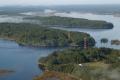
The Upper Kennebec Estuary

© Heather Perry MMB_006
Six rivers – the Kennebec, Androscoggin, Cathance, Abagadasset, Muddy and Eastern – converge to form Merrymeeting Bay in the upper Kennebec estuary. This inland body of fresh and brackish tidal waters drains nearly forty percent of Maine, creating shallow, nutrient rich waters, expanses of wild rice, and more than 4,500 acres of prime waterfowl habitat.
Explore the Upper Kennebec Estuary
-

© Heather Perry (MMB_014)
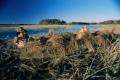
Merrymeeting Bay
by Beginning with Habitat
At the heart of the Kennebec Estuary lies Merrymeeting Bay, where six rivers draining one-third of the state of Maine converge to form an inland, freshwater, tidal delta. -

© Heather Perry (DSC_0136 (1))
Cathance River
by Beginning with Habitat
With its Abenaki name meaning "crooked river," the Cathance is a roaming 20-mile river whose watershed contains habitats for rare plants, waterfowl, mammals, amphibians, bald eagles, and other flora and fauna. -
© Heather Perry (DSC_0120)
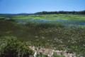
Chops Creek
by Beginning with Habitat
A 100-acre freshwater tidal marsh dominated by American bulrush and wild rice with the highest abundance of submerged aquatic vegetation on Merrymeeting Bay extends along much of Chops Creek. -
© Heather Perry (MMB_004)
Eastern River
by Beginning with Habitat
Well known as a wintering area for bald eagles, the Eastern River also features numerous rare plants and a freshwater tidal marsh. -
© Heather Perry (9.5REDONE)
Abadagasset Point to Pork Point
by Beginning with Habitat
The cove on the north side of Abadagasset Point has a broad, extensive tidal flat of approximately 200 acres with bands of vegetation. -
Swan Island
by Beginning with Habitat
The site of a small, abandoned town formerly known as Perkins Township, Swan Island is well known for its abundant and often quite visible wildlife, especially nesting bald eagles, white-tailed deer, and wild turkey. -
Lines Island
by Beginning with Habitat
Along the southeast side of Lines Island is a 20-acre freshwater tidal marsh with some of the bay's largest populations of rare plants.
Go to the Map

Use the interactive map to zoom smoothly from a national view to state and local perspectives anywhere across the country.

