

 © Pete Saloutos/Panoramic Images (Maine Title Image Large)
Kennebec Estuary
© Heather Perry Kennebec Estuary Featured Image
The Kennebec Estuary's extensive estuarine system is one of Maine's most significant and unique natural areas, containing over 20 percent of Maine's tidal marshes, a significant percentage of Maine’s sandy beach and associated dune habitats, and globally rare pitch pine woodland communities. This diverse complex of rare and exemplary natural communities provides critical habitat for several endangered and threatened animal species, from piping plovers and least terns along the sandy shoreline to the short-nosed sturgeon and bald eagles of Merrymeeting Bay.
Along with the mainstem of the Kennebec River, the estuary encompasses hundreds of miles of tidal frontage along its many inlets and tributaries. The varied terrain and mixing of fresh and salt waters supports 25,000 acres of prime waterfowl habitat, unusual freshwater tidal conditions, and one of the few places in the world where major rivers come together to form an enclosed tidal delta.
The estuary faces ever-increasing development pressures, as more residential and second homes are built along Maine’s coast, damaging the fragile habitat and threatening a way of life. Inappropriate recreational use and non-native species also pose significant threats to the estuary's habitat and wildlife.
Conservation priorities in the estuary include habitat for migratory fish, undeveloped shoreline for bald eagle nesting and roosting, intact beaches and dunes, freshwater and saltwater tidal marshes, and the upland forests that buffer these shoreline ecosystems and provide habitat for a variety of songbirds, mammals and more. These conservation properties also provide recreational opportunities, including fishing, hunting, and hiking, and protect clam flats, drinking water and community-based agriculture.
Download Beginning with Habitat Focus Area Description
More about the Kennebec Estuary
-

© Heather Perry (MMB_006)
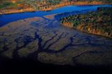
The Upper Kennebec Estuary
Six rivers -- the Kennebec, Androscoggin, Cathance, Abagadasset, Muddy and Eastern -- converge in a shared delta to form Merrymeeting Bay in the upper Kennebec estuary.
-

© Heather Perry (Burke0705.013)
The Lower Kennebec Estuary
Diverse habitats and tidal influence make the Lower Kennebec Estuary a fantastically rich mixing place for plants and animals both common and rare.
-

© Heather Perry (DSC_0148)
Kennebec Headlands and Beaches
As the Kennebec broadens and sweeps seaward, it opens to a maritime region of forested headlands with magnificent views, smooth hard beaches, salt marshes, and small bays.
-
© Heather Perry (9.2-2)
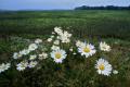
Stuck in the Mud: Rare Plants of Merrymeeting Bay
by Andy Cutko
As scenic as Merrymeeting Bay is, some of its most notable plants distinctly lack appeal, with names and habitats that do anything but evoke images of nature's splendor.
Priority Places within the Estuary
-
Merrymeeting Bay
by Beginning with Habitat
-
Cathance River
by Beginning with Habitat
-
Chops Creek
by Beginning with Habitat
-
Eastern River
by Beginning with Habitat
-
Lines Island
by Beginning with Habitat
-
Abadagasset Point to Pork Point
by Beginning with Habitat
-
Swan Island
by Beginning with Habitat
-
Back River and Hockomock Bay
by Beginning with Habitat
-
Pleasant Cove, Woolwich
by Beginning with Habitat
-
Newtown and Minot Creeks and Tarrs Mountain, Arrowsic
by Beginning with Habitat
-
Preble Point, Arrowsic
by Beginning with Habitat
-
The Basin Preserve
by Beginning with Habitat
-
Popham Beach
by Beginning with Habitat
-
Morse Mountain and Seawall Beach to Small Point
by Beginning with Habitat
-
Little River
by Beginning with Habitat
Go to the Map

Use the interactive map to zoom smoothly from a national view to state and local perspectives anywhere across the country.

