

 © Steve Vaughn/Panoramic Images (Florida Title Image Large)
Watersheds of Florida
© Paul Russo/FNAI Watersheds in Florida Featured Image
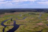
What is a watershed?
A watershed is determined by water flow and is the geographic area within which all water flows to a common location such as a stream, river, lake, or ocean. Watersheds are divided from each other by the high points of land surrounding each watershed. Depending on the scale of interest, a watershed can refer to a neighborhood gully with an intermittent stream or to the US continental divide in the Rocky Mountains which determines whether rainfall flows into either the Pacific Ocean or the Atlantic Ocean.
In Florida, watersheds are complicated by the presence of disjointed drainage systems. Much of northern Florida has karst topography, which some describe as a geologic sponge. Water within a watershed underlain by karst topography can flow into a sinkhole and flow underground before emerging elsewhere in a spring. It is estimated there are more than 700 freshwater springs in Florida, the most of any place on Earth. Wakulla Springs near Tallahassee is one of the largest freshwater springs in the world with a discharge of over 400,000 gallons of water per minute.
Why watersheds are important
Larger-scaled land management is often based on watershed boundaries because any activity that impacts the water within the watershed is likely to ultimately affect all the inhabitants of that watershed. Whether water is diverted for agriculture, is pumped out of the ground for drinking, or is polluted due to storm water runoff, the use of the water resources within a watershed ultimately affects all downstream inhabitants, even those that reside in adjacent downstream watersheds.
Florida’s Watersheds
Florida has 29 major watersheds. The Apalachicola–Chipola River watershed contains the state’s largest river in terms of flow. Its waters originate in Georgia and the watershed has many plant and animal species more typical of the southern Appalachian Mountains than of Florida. Its high biological diversity prompted the United Nations to designate this watershed as a biosphere reserve.
Other watersheds in Florida are less clearly defined, due in part to disjointed drainage systems or atypical elevation gradients. Where watersheds in north Florida sit atop karst topography, the lowering of the water table can, in extreme instances, lead to houses or roads falling into sinkholes. Watersheds in southern peninsular Florida are characterized by low elevational gradients. For example, the Everglades watershed historically flowed as a sheet of water over a large area rather than confined flows in a stream channel. Attempts to alter the functioning of these watersheds led to the devastation of the Everglades and spurred current initiatives to restore this unique ecosystem through the Comprehensive Everglades Restoration Plan (CERP).
Watershed Issues of Florida
Florida watersheds are facing many of the same issues as watersheds throughout the U.S., such as non-point source pollution, storm water runoff, increased demand and inter-basin water transfers. By increasing water diversion from the Flint River for an ever-growing population, the city of Atlanta is reducing water flow into the Apalachicola–Chipola River watershed. The action has prompted a multi-state lawsuit involving Florida, Georgia and Alabama. Intense debate surrounding water issues has even arisen within Florida, such as when The Florida Council of 100 floated the idea of a statewide water distribution plan. The proposal would have benefitted residents of populous southern Florida who often find water a scarce resource.
Explore Florida's Watersheds
Florida Department of Environmental Protection Watershed Description
Watershed Monitoring Basin Reports
The Florida Department of Environmental Protection’s watershed monitoring basin reports summarize the network monitoring results for surface water and ground water. This interactive map shows the 29 watershed monitoring basins.
Florida's Watersheds and Conservation:
Comprehensive Everglades Restoration Plan
The Comprehensive Everglades Restoration Plan (CERP) provides a framework and guide to restore, protect and preserve the water resources of central and southern Florida, including the Everglades. The goal of CERP is to capture fresh water that now flows unused to the ocean and the gulf and redirect it to areas that need it most.
Apalachicola-Chattahoochee-Flint River System
Florida Department of Environmental Protection description, timeline, and information on the Apalachicola-Chattahoochee-Flint River System Lawsuit.
The Florida Council of 100
Water Atlas of Florida
Visit Florida's Water Management District Websites:
Northwest Florida Water Management District
South Florida Water Management District
Southwest Florida Water Management District
Go to the Map

Use the interactive map to zoom smoothly from a national view to state and local perspectives anywhere across the country.
Go Straight to Your State
Learn about conservation and open space in your state.
Contribute to LandScope

Want to join, work with us or simply find out more? Learn how you can get involved.
