 © Louis Vest (LandScope Texas Banner)
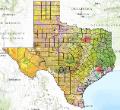
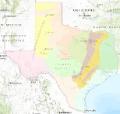
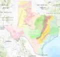
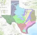
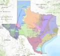
Ecoregions of Texas
Due to its size and geographic location, Texas is unique among the states. Fifteen of the 50 states could fit within its borders. The state has impressive topographic diversity, including 91 mountain peaks that are a mile or more high, and its location is also important in that eastern habitats meet western ones and southern subtropical habitats meet northern temperate ones.
With 12 distinct ecoregions covering approximately 268,500 square miles, Texas has an astounding array of climates, soils and habitats. High plains, wetlands, mountains, deserts, forests and coastal marshes provide habitat for the fish and wildlife resources that help define the landscape.
Ecoregions reflect broad ecological patterns occurring on the landscape. Using ecoregions as a framework for assessing the distribution and status of species and ecosystems makes biological sense, compared to using political lines such as county, state, or national boundaries.