 © Louis Vest (LandScope Texas Banner)
Texas Ecological Mapping Systems
Overview
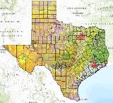
Vegetation communities of Texas.
Data Layer Description
Source

Texas Parks and Wildlife Department (TPWD) and Missouri Resource Assessment Partnership (MoRAP).
Location
Texas
Description
This data is a detailed and comprehensive raster map of the vegetation communities of Texas produced by Texas Parks and Wildlife Department (TMWD) and Missouri Resource Assessment Partnership (MoRAP).
How to get the data layer
These data and others can be downloaded from the Texas Parks and Wildlife Department’s website:
http://www.tpwd.state.tx.us/gis/data/downloads
How to get more information
For more information, contact the Texas Parks and Wildlife Department GIS Lab.
Credits
TPWD and MoRAP personnel created the dataset.
Sample Map