 © Louis Vest (LandScope Texas Banner)
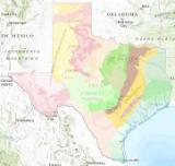
Level IV Ecoregions of Texas
Overview
Ecoregions are hierarchical, with Level IV being the most detailed and Level I defining the broadest classifications. Because of this hierarchy, Level IV features include appropriate codes and names for Levels III, II, and I. Likewise, Level III features contain Levels II and I, and Level II retains Level I information. Attributes pertaining to Level IV are only available for the Conterminous United States (US_). Level III has attributes for the US and North America (NA_) while Levels II and I apply to only North America. All features are identified by State and EPA Administrative Regions, as well. Fields ending with "KEY" combine ecoregion code and name attributes for convenient legends and are linked to style and layer files containing color definitions.
Data Layer Description
Source

U.S. EPA Office of Research and Development (ORD) - National Health and Environmental Effects Research Laboratory (NHEERL)
Location
Texas
Description
Ecoregions by state were extracted from the seamless national shapefile. Ecoregions denote areas of general similarity in ecosystems and in the type, quality, and quantity of environmental resources. They are designed to serve as a spatial framework for the research, assessment, management, and monitoring of ecosystems and ecosystem components. These general purpose regions are critical for structuring and implementing ecosystem management strategies across federal agencies, state agencies, and nongovernment organizations that are responsible for different types of resources within the same geographical areas. The approach used to compile this map is based on the premise that ecological regions can be identified through the analysis of patterns of biotic and abiotic phenomena, including geology, physiography, vegetation, climate, soils, land use, wildlife, and hydrology. The relative importance of each characteristic varies from one ecological region to another. A Roman numeral hierarchical scheme has been adopted for different levels for ecological regions. Level I is the coarsest level, dividing North America into 15 ecological regions. Level II divides the continent into 50 regions (Commission for Environmental Cooperation Working Group, 1997). At Level III, the continental United States contains 105 regions whereas the conterminous United States has 85 (U.S. Environmental Protection Agency, 2011). Level IV ecoregions are further subdivisions of Level III ecoregions. Methods used to define the ecoregions are explained in Omernik (1995, 2004), Omernik and others (2000), and Gallant and others (1989).
How to get the data layer
These data can be downloaded from the EPA website:
ftp://ftp.epa.gov/wed/ecoregions/tx/tx_eco_l3.zip
How you might make use of this data layer
Ecoregion maps assist managers of aquatic and terrestrial resources to understand the regional patterns of the realistically attainable quality of these resources.
How to get more information
Electronic versions of ecoregion maps and posters as well as other ecoregion resources are available at: http://www.epa.gov/wed/pages/ecoregions.htm. Except for the Great Lakes, waterbodies were merged with surrounding ecoregion polygons, especially along coastlines. Ecoregions were digitized at 1:250,000 scale and are intended for large geographic extents (i.e. states, multiple counties, or river basins). Use for smaller areas, such as individual counties or a 1:24,000 scale map boundary, is not recommended.
Access and use constraints
None
Credits
U.S. Environmental Protection Agency.
Sample Map