

 © Mike Norton (Colorado)
Ecoregions of Colorado
© Charlie Johnson Ecoregions in Colorado Featured Image
What are ecoregions?
Ecoregions reflect broad ecological patterns occurring on the landscape. In general, each ecoregion has a distinctive composition and pattern of plant and animal species distribution. Abiotic factors, such as climate, landform, soil, and hydrology are important in the development of ecosystems, and thus help define ecoregions. Within an individual ecoregion, the ecological relationships between species and their physical environment are essentially similar.
Why use ecoregions?
Using ecoregions as a framework for assessing the distribution and status of species and ecosystems makes biological sense, compared to using politically derived lines like county, state or national boundaries. Ecoregions also provide an ecological basis for partitioning the state into subunits for conservation planning purposes.
Ecoregions of Colorado
-
Central Shortgrass Prairie
A broad expanse of rolling plains and tablelands dissected by streams, canyons, badlands, and buttes, the Central Shortgrass Prairie ecoregion spans eight states on the west-central edge of the Great Plains.
-
Utah-Wyoming Rocky Mountains Ecoregion
The Utah-Wyoming Rocky Mountains Ecoregion includes the mountains four states, and includes the Greater Yellowstone Ecosystem (GYE), considered one of the last intact temperate ecosystems on Earth, and the farthest south in North America. Yellowstone is an extraordinary place containing the greatest concentration of geysers, hot springs, and other thermal features in the world. Not surprisingly it is a World Heritage Site.
-
Wyoming Basins Ecoregion
The Wyoming Basins ecoregion comprises 51,605 square miles of basin, plain, desert, and island mountains in Wyoming, Montana, Idaho, Colorado, and Utah.
-
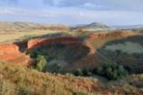
Colorado Plateau Ecoregion
The Colorado Plateau falls primarily within the Colorado River watershed, which defines much of its mid-elevation character between the Rocky Mountains (eastward) and the Mojave and Sonoran Deserts (southwestward). To the north and northwest, a grand staircase of cliffs ascends into the adjacent Utah High Plateaus.
-
Southern Rocky Mountains Ecoregion
With a rapid elevation gain of nearly 9,800 ft, the eastern flank of the Southern Rocky Mountains ecoregion is an impressive sight for travelers heading west across the eastern plains. Colorado encompasses 73.5% of the ecoregion, New Mexico 18%, and Wyoming 8.5%.
Go to the Map

Use the interactive map to zoom smoothly from a national view to state and local perspectives anywhere across the country.

