

EPA Enviroatlas
EPA Enviroatlas
The EnviroAtlas is a web-based, easy-to-use, mapping application now in development that will allow users to view and analyze multiple ecosystem services in a specific region. The Atlas will provide users with a visual method for interpreting ecosystem services and understanding how they can be conserved and enhanced for a sustainable future. The maps will provide users with an ability to assess:
- Clean and adequate water for drinking and domestic use
- Clean water for recreation and aquatic habitat
- Food, fuel and fiber
- Recreation, cultural and aesthetic amenities
- Climate regulation (e.g. carbon storage to off-set greenhouse gases)
- Protection from hazardous weather
- Habitat and the maintenance of biodiversity
- Clean air
Enviroatlas Content on LandScope
-
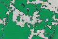
© U.S. Environmental Protection Agency (Green Infrastructure Connectivity Sample Map)
Connectivity, Natural Land Cover 2006, Water Ignored
This nationally focused green infrastructure assessment adds context lost when political boundaries are imposed.
-
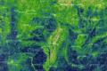
© U.S. Environmental Protection Agency (Riparian Integrity by Subwatershed Sample Map)
Percent Stream Buffer Zone as Natural Land Cover
This layer describes the amount of natural land cover contained within a buffer area extending 30 meters to each side of all streams contained within a river basin.