

Conservation Map of the U.S.
Conservation Map of the U.S.
This compelling new map, produced by the National Geographic Society and NatureServe, tells the story of the changing face of land conservation in the United States. The map documents continuing threats to our nation’s open space while also highlighting some of America’s greatest natural places and how we, the people, are protecting them.
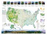
Natural States of America
The American landscape is incomparably rich and varied. From the Gulf Coast to the Great Plains, Atlantic to Pacific, Arctic tundra to Hawaiian Islands, our natural heritage is captured in song and story and in the national imagination.
This side of the map depicts protected areas of the U.S., both public and private, as well as key trends in land protection activity, including the accomplishments of the nation’s 1,700 land trusts. It features descriptions of the major ecological divisions of the U.S., with a stunning photographic “transect” of the nation’s diverse ecosystems. Inset maps highlight imperiled species hotspots, vertebrate species richness, dollar investments in open space, and land trust activity across the country.
Download the Natural States of America map (PDF, 1.6MB)
Open Space at Risk
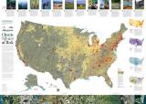
From panoramic western landscapes to urban pocket parks, America’s open spaces are a cherished part of our national and local identities. Forest, wetlands, and other natural lands provide people with essential services, including pure water, abundant wildlife, and a moderating influence on our changing climate.
Yet our open spaces—rural, urban, and suburban—are dwindling rapidly. Each year about two million acres are converted to other uses—nearly 6,000 acres a day. This map explores key threats to open space—including development pressure, oil and gas exploration, and conversion to industrial agriculture. Inset maps show projected residential development in 2030, areas most vulnerable to climate change, severely altered river flows, and the spread of invasive species. The map also highlights a dozen success stories from across America that provide hope and examples of innovative conservation action.
Download the Open Space at Risk map (PDF, 2.8MB)
To Order a Copy
Visit the National Geographic Maps website to order a copy to receive by mail.
More about the Conservation Map
-
Acknowledgments and Sources | Conservation Map of the U.S
We thank the many groups who provided data and assistance for the map, especially Colorado State University, the Conservation Biology Institute, IHS Inc., the Land Trust Alliance, The Trust for Public Land, The Nature Conservancy, the U.S. Forest Service, and the U.S. Geological Survey. Thanks also to ESRI for its support in printing this map.
Map Featured by Land Trust Alliance
The Conservation Map of the U.S. was recently featured in an article in Saving Land, the magazine of the Land Trust Alliance. Each subscriber received a copy of the map along with the magazine. Read the full text of the article.
Go to the Map

Use the interactive map to zoom smoothly from a national view to state and local perspectives anywhere across the country.
Go Straight to Your State
Learn about conservation and open space in your state.
Receive Email Updates

Stay up to date with the latest at LandScope America by entering your email below.
Contribute to LandScope

Want to join, work with us or simply find out more? Learn how you can get involved.
