

 © Louis Vest (LandScope Texas Banner)
Windmills
Overview
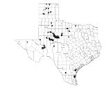
This dataset shows the locations of each windmill structure in Texas.
Data Layer Description
Source

Federal Aviation Administration (FAA)
Location
Texas
Description
This data layer represents wind energy structures in Texas as of March 2012. This data layer was created for the Terrain and Obstacles Data (TOD) Team within the FAA. As a part of this layer the wind turbines (windmills) were exported and displayed as a separate shapefile (see Sample Map below) to show where wind energy sources were located. The point data was digitized by the Texas Parks and Wildlife Department (TPWD).
How to get the data layer
Contact the TPWD GIS Lab Manager, Kim Ludeke.
How you might make use of this data layer
This data layer provides locations for windmill structures in Texas and can be used as a reference to locate where possible areas of high winds are prevalent.
How to get more information
For a detailed description of the TOD Team and their data visit their website.
Credits
Federal Aviation Administration. March 2012. Terrain and Obstacles Data Team.
Sample Map
© Federal Aviation Administration Windmills

