

Rocky Mountains
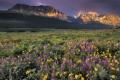
Meriwether Lewis, upon first sighting the spine of the continent on May 26, 1805 wrote: “These points of the Rocky Mountains were covered with snow and the sun shone on it in such manner as to give me the most plain and satisfactory view.” Visitors have marveled ever since at these jagged-peaked ranges separated by glacier-carved valleys. Douglas fir and ponderosa pine forests at lower elevations, montane grasslands, subalpine forests of spruce-fir or lodgepole pine, and alpine tundra are all characteristic of this greatest North American range.
Location
The ”spine of the continent” extending from the Canadian Rocky Mountains south to Yellowstone, the Wasatch and Uintah ranges, the Big Horn mountains, and Black Hills, then south through the Southern Rocky Mountains and isolated ranges of central Arizona and southern New Mexico.
Climate
Climate includes wide extremes from severe, snow-packed winters to mild summers. Average annual temperature of -7ºC (19.4ºF) with mean annual precipitation of 752mm (30 inches) at Pikes Peak, Colorado, elevation 4300m or 14,107 feet.
Features
Extensive high mountain ranges with scattered small glaciers and jagged peaks, then deep glacier-carved valleys. Snowpack provides significant annual runoff for major river basins, such as the Columbia, Colorado, Missouri, Platte, Arkansas, and Rio Grande. Alpine tundra, subalpine spruce-fir and lodgepole pine forests, montane grasslands, and mixed conifer forests of Douglas fir, ponderosa pine, western red-cedar, and western hemlock predominate. Wildfire remains common, especially after insect outbreaks and drought-stressed trees become most vulnerable. Lower elevation forests of ponderosa pine likely burned with frequent ground fires, often forming open grass-dominated savannas.
History and Trends
Region was often treated as hunting grounds by Native American communities from nearby valleys and plains. The mining boom occurred in the late 1800s, followed by logging and development of intermountain valleys. In southern mountains, traditional grazing by sheep and cattle has been extensive. National Forests and National Parks predominate land ownership patterns in the US.
Rocky Mountains Ecoregions
-
© Florian Schulz (Middle Rockies - Blue Mountains Featured Image)
Middle Rockies - Blue Mountains
The Middle Rockies - Blue Mountains Ecoregion represents a large mass of rugged mountains and intermontane valleys covering major portions of Oregon, Idaho, and Montana, and a small part of Washington.
-
Okanagan Ecoregion
The Okanagan Ecoregion lies east of the crest of the Coast and Cascade Mountain ranges and west of the Columbia and Selkirk Mountains. The ecoregion is characterized by long, rounded ridges, rolling plateaus, wide valleys, and large lakes with the Thompson-Okanagan Plateau in the northeast and the Okanagan Highlands in the southeast.
-
Southern Rocky Mountains Ecoregion
With a rapid elevation gain of nearly 9,800 ft, the eastern flank of the Southern Rocky Mountains ecoregion is an impressive sight for travelers heading west across the eastern plains. Colorado encompasses 73.5% of the ecoregion, New Mexico 18%, and Wyoming 8.5%.
-
Utah-Wyoming Rocky Mountains Ecoregion
The Utah-Wyoming Rocky Mountains Ecoregion includes the mountains four states, and includes the Greater Yellowstone Ecosystem (GYE), considered one of the last intact temperate ecosystems on Earth, and the farthest south in North America. Yellowstone is an extraordinary place containing the greatest concentration of geysers, hot springs, and other thermal features in the world. Not surprisingly it is a World Heritage Site.