

 © Bruce McNitt/Panoramic Images (Virginia)
Virginia Important Bird Areas
Overview
This data layer was created by the National Audubon Society’s Virginia Important Bird Areas (IBA) Program in an effort to inform environmental planners, resource managers and other interested parties of the Commonwealth of Virginia’s IBAs. These critical areas of habitat for breeding, wintering or migrating birds have been identified as part of an international endeavor headed by BirdLife International.
Data Layer Description
Source

The Virginia Important Bird Areas (IBA) Program of the National Audubon Society
What this data layer represents
Important Bird Areas, or IBAs, are sites that provide essential habitat for one or more species of birds. IBAs may be a few acres or thousands of acres, but they are usually discrete sites that stand out from the surrounding landscape. IBAs may include public or private lands, or both, and they may be protected or unprotected.
Location
Virginia
Description
In order to identify and protect those areas of the Commonwealth of Virginia that provide the most essential habitat for nesting, migrating or wintering birds, the Virginia Important Bird Areas (IBA) Program was created in 2002 by way of partnerships between the Virginia Audubon Council, Virginia Society of Ornithology, Virginia Department of Game and Inland Fisheries, and the National Audubon Society as part of a global imporant bird area effort headed by BirdLife International.
Since its inception in 2002, the Virginia IBA Program has worked to identify 20 IBAs that cover over 12% of the Commonwealth’s lands, all of which can be seen in this data layer. IBAs are typically nominated and delineated based upon habitat and specific species criteria. Nominated IBAs then go to vote before a state technical committee of experts in the fields of ecology, natural resources, ornithology, etc., that includes representatives from the federal government, state government agencies, non-profits and academia.
Once an IBA is reviewed and accepted by the technical committee, it then becomes an officially identified State-level Important Bird Area. Further review by the National Audubon Society’s United States IBA Committee could result in the prioritization (or ranking) of an IBA on the Continental or Global level. This process is continually on-going and the statuses of IBAs change through time.
Get up-to-date information on each of Virginia’s IBAs
How to get the data layer
A shapefile of the Virginia Important Bird Areas (IBAs) is available upon request to Mary Elfner, Virginia IBA Coordinator.
There are no restrictions or legal requirements for accessing this data. However, potential data users should contact the coordinator if they plan on using this dataset for purposes other than supporting the Virginia IBA Program.
How you might make use of this data layer
The Virginia Important Bird Areas (IBAs) were identified in an effort to bring attention to the Commonwealth of Virginia’s most essential habitats for breeding, migrating or wintering birds. In order to be designated as an Important Bird Area, each IBA must meet specific species criteria and pass the judgment of a state technical committee of experts in the field. Nonetheless, each IBA is very unique. Some IBAs have been delineated based upon habitat models or landscape features, while others have been outlined using political or property boundaries. IBAs may be composed of both private and public lands and may include both protected and unprotected areas. Therefore, Virginia’s IBAs face a variety of conservation issues that are unique on an IBA by IBA basis.
Please consider using this data layer while considering land acquisition, restoration, and protection strategies, most especially at the landscape scale. This data may also be used as an input layer in future county- or state-level studies of bird and wildlife habitat conservation priorities. Local government planners in particular should use this information while completing the environmental planning portions of their county or city’s state-mandated comprehensive plans.
How to get more information
Mary A. Elfner
Virginia IBA Coordinator
(804)-766-7880
Sample Map
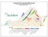
© National Audubon Society Virginia IBA Sample Map

