

 © Louis Vest (LandScope Texas Banner)
Recommended Reservoir Sites
Overview
Sites recommended in the 2012 State Water Plan for dam/reservoir construction.
Data Layer Description
Source

Texas Water Development Board (TWDB)
Location
Texas
Description
This data layer was created in 2008 and represents sites that could be threatened, along with their aquatic species and riparian habitats, if reservoir construction were done. Recommended and created by TWDB.
How to get the data layer
Publication report #370 provided by the TWDB has raw data available.
How you might make use of this data layer
This dataset is beneficial because it identifies sites that could be threatened by construction.
How to get more information
Visit the TWDB’s GIS website.
Credits
Texas Water Development Board. 2008.
Sample Map
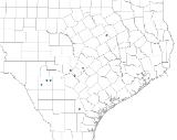
© Texas Water Development Board Recommended Reservoir Sites

