

 © Louis Vest (LandScope Texas Banner)
Municipal Solid Waste Sites and Landfills
Overview
This layer contains all permitted or registered landfills and associated Municipal Solid Waste (MSW) facilities for the State of Texas.
Data Layer Description
Source

Texas Commission on Environmental Quality (TCEQ)
Location
Texas
Description
This data layer, created in April 2007, represents threats in Texas in the form of municipal solid waste and landfill sites. The general purpose use of this data is to support agency-wide policy decisions regarding municipal solid waste in the State of Texas. Acknowledgement of TCEQ is appreciated on any products using this dataset. This data layer contains all permitted or registered landfills and associated municipal solid waste facilities for Texas as of the April 2007. The dataset contains both closed and open landfills. The associated facilities represent various categories including transfer stations, waste processing facilities, and recycling centers. The following represents the horizontal accuracy of this dataset: 53% - based on DRGs (12 meter accuracy) 12% - address matching (10-meter accuracy) 35% - coordinates reported by Operator (accuracy unknown).
How to get the data layer
This data set and others are located on the TCEQ Site Layers Page.
How you might make use of this data layer
This data layer can be used to assess harmful waste sites and landfills located in a specific area of interest.
How to get more information
See TCEQ’s Data website.
Credits
Texas Commission on Environmental Quality. April 2007.
Sample Map
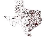
© Texas Commission on Environmental Quality Municipal Solid Waste Sites and Landfills

