

 © Louis Vest (LandScope Texas Banner)
Texas Species Habitat
Overview
Coastal distribution of animals, plants, and habitats potentially at risk from oil spill damage or response activities.
Data Layer Description
Source
Texas General Land Office (TGLO)
Location
Texas Gulf Coast
Description
These points represent the occurrence/distribution of animals, plants and/or plant communities in areas adjacent to coastal bays and the Gulf of Mexico in Texas. Defined and digitized by TGLO personnel. All data was based on consultation with representatives of Texas Parks and Wildlife Department, the General Land Office, U.S. Fish and Wildlife Service, plus more than 30 other public agencies, academic institutions, and private groups and citizens.
How to get the data layer
This data can be found on the TGLO's GIS Lab's website.
How you might make use of this data layer
This dataset provides biogeographical point data for the use of identifying coastal species habitat, occurrences, and distribution.
How to get more information
The TGLO’s Online Map Viewer.
Credits
Texas General Land Office. 1994-1995.
Sample Map
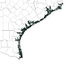
© Texas General Land Office Texas Gulf Coast Species Habitat

