

 © Louis Vest (LandScope Texas Banner)
Golden cheeked Warbler Probability of Occurrence
Overview
This dataset is a Golden-cheeked warbler occupancy model within patches of potential habitat across the breeding range in Texas.
Data Layer Description
Source

Texas A&M Institute of Renewable Natural Resources
Location
Texas
Description
Potential habitat was derived from a mosaic of Landsat 5 imagery collected in the spring of 2007 and 2008. Patch metrics such as area, perimeter, landscape composition, patch proximity index, etc. were calculate for potential habitat. The occupancy model is based upon warbler survey data collected in 2008 and 2009 under a rigorous sampling design and three patch metrics: patch size, landscape composition, and spatial location within the range. From this, the distribution of patches across the range can be identified and associated rates of expected warbler presence can be determined. Additionally, because this approach incorporates spatial location, patches having similar size and landscape composition but located in different regions of the state will not necessarily have the same probability of occupancy.
How to get the data layer
Contact Tiffany McFarland at the Texas A&M Institute of Renewable Natural Resources (College Station, TX).
How you might make use of this data layer
This dataset was collected as part of research sponsored by the Texas Department of Transportation. The primary objective of this research was to estimate Golden-cheeked warbler distribution across the species’ breeding range in Texas.
How to get more information
For a detailed explanation of methods used to develop the occupancy model, refer to the following report submitted to the Texas Department of Transportation in July 2010: Morrison, M. L., R. N. Wilkins, B. A. Collier, J. E. Groce, H. A. Mathewson, T. M. McFarland, A. G. Snelgrove, R. T. Snelgrove, and K. L. Skow. 2010. Golden-cheeked warbler population distribution and abundance. Texas A&M Institute of Renewable Natural Resources, College Station, Texas, USA. This report is available online.
Access and use constraints
Attribution Non-Comm. No Deriv. (BY-NC-ND) This license is the most restrictive, allowing redistribution. This license allows others to download our works and share them with others as long as they mention us and link back to us, but they cannot change them in any way or use them commercially. (http://creativecommons.org/licenses/by-nc-nd/3.0/)
Credits
Texas A&M Institute of Renewable Natural Resources. July 2010.
Sample Map
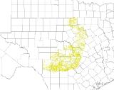
© Texas A&M Institute of Renewable Natural Resources Golden-cheeked Warbler Occupancy

