 © Louis Vest (LandScope Texas Banner)
Texas Playas
Overview
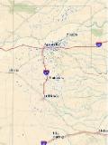
Delineation of High Plains Playa lakes during mid-winter duck surveys.
Data Layer Description
Source

Texas Parks and Wildlife Department (TPWD)
Location
Texas High Plains
Description
The playa lakes of the Texas High Plains extend from the northern Panhandle to the Trans-Pecos and Edwards Plateau. Playa lakes are shallow, flat-bottom, circular shaped ephemeral wetlands, which provide critical wildlife habitat. Playa lakes occur where inundated clay soils form seals trapping water in surficial depressions. The playa data in this coverage were derived from 1999-2001 Landsat ETM imagery and the 1998 Texas Tech Playa Lake Study (http://www.gstlab.rw.ttu.edu/playas.pdf). Scale is 1:50,000.
How to get the data layer
http://tpwd.texas.gov/gis/data/
How to get more information
For more information on the dataset, contact the TPWD GIS Lab.
Credits
Sample Map