 © Louis Vest (LandScope Texas Banner)
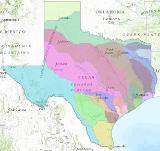
Texas Major River Basins
Overview
This dataset is for use by the Texas Water Development Board.
Data Layer Description
Source

U.S. Geological Survey.
Location
Texas
Description
This dataset represents the boundaries for the river basins of Texas. It was developed by the U.S. Geological Survey.
How to get the data layer
These data and others can be downloaded from the Texas Water Development Board’s website:
http://www.twdb.texas.gov/mapping/gisdata.asp
Credits
U.S. Geological Survey.
Sample Map