 © Louis Vest (LandScope Texas Banner)
Minor Bays
Overview
This feature class is a component of TPWD 'base' data. 'Base' data includes current, statewide geospatial information intended to provided context for mapping purposes.The Coastal Fisheries Division used this feature class to provide better resolution for mapping harvest monitoring database.
Data Layer Description
Source

Texas Parks and Wildlife Department, Coastal Fisheries Division
Description
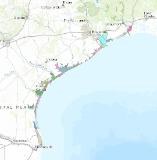
This feature class defines minor bays along the Texas Gulf Coast.
How to get the data layer
Texas Parks and Wildllife GIS Lab
Access and use constraints
This data was prepared for inclusion in the TPWD Base SDE database by Texas Parks and Wildlife Department GIS analysts. The Texas Parks and Wildlife Department, its employees, and personnel, make no warranty as to its accuracy. The Texas Parks and Wildlife Department, its employees, and personnel MAKE NO WARRANTY FOR FITNESS OF USE FOR A PARTICULAR PURPOSE EXPRESS OR IMPLIED WITH RESPECT TO THIS DATA. THIS IS NOT A SURVEYED PRODUCT. Title 1 Part 10 Chapter 201 Rule §201.6 of the Texas Administrative Code suggests data showing the full extent of Texas be projected in the Texas State Mapping System. This feature class as provided by TPWD is unprojected.Note that this data is not intended for navigational use. The original intention of this data set is to display harvest monitoring database query results.
Credits
Erik O'Brian- initial revision; Christian Hager-further revision; Andrew Shaw- remaining revisions and documentation; Ashley Summers- revision to ULM 2010; References_Cited constituent coverage citations: esi-beg: from tnris web site (nwi?) http://www.tnris.state.tx.us/ txdot: from tnris web site; provide majority of linework missing from nwi cov. noaa: from digital nautical charts (for channel markers, beacons, etc.) usgs: from 1:24k drgs doqq: 1m digital ortho quarter quads TPWD counties 2004 layer
Sample Map