 © Louis Vest (LandScope Texas Banner)
Springs
Overview
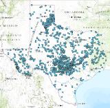
The purpose of this project is to aggregate information about springs in Texas and associated spring flow into a digital database. This feature class is a component of TPWD 'base' data. 'Base' data includes current, statewide geospatial information intended to provide context for mapping purposes.
Data Layer Description
Source

Texas Parks and Wildlife Department
Description
Springs are naturally occurring features that convey excess ground water to the land surface; they represent a transition from ground water to surface water. Water issues through one opening, multiple openings, or numerous seeps in the rock or soil.
How to get the data layer
Texas Parks and Wildlife Department GIS Lab
Access and use constraints
This dataset should not be used to make final decisions on the existence of springs in Texas. Other springs exist in Texas, but are not recorded in this project. This data was prepared for inclusion in the TPWD Base SDE database by the Texas Parks and Wildlife Department GIS Lab. The Texas Parks and Wildlife Department, its employees, and personnel, make no warranty as to its accuracy. The Texas Parks & Wildlife Department, its employees, and personnel MAKE NO WARRANTY FOR FITNESS OF USE FOR A PARTICULAR PURPOSE EXPRESS OR IMPLIED WITH RESPECT TO THIS DATA. THIS IS NOT A SURVEYED PRODUCT. Title 1 Part 10 Chapter 201 Rule §201.6 of the Texas Admnistrative Code suggests data showing the full extent of Texas be projected in the Texas State Mapping System. This feature class is provided by TPWD is unprojected.
Credits
Texas Parks and Wildlife Department GIS Lab
Sample Map