

Delaware Agricultural Easements
Overview
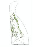
This polygon shape file is a tax parcel based representation of the lands that are preserved by the Delaware Agricultural Lands Preservation Foundation (DALPF). These lands include farms that have sold or donated their development rights to the Foundation as well as farms that agree not to develop their land for a period of ten years.
Data Layer Description
Source
Delaware Department of Agriculture, Land Use Planning & Preservation Section (originator, Thompson Mapping Systems, Inc.)
Location
Delaware
How to get the data layer
Download here.
How you might make use of this data layer
This data is used for general mapping purposes, development of land use strategies.
How to get more information
Contact Barb Carrigan.
Sample Map
© Delaware Department of Agriculture, Land Use Plann Agricultural Easements

