

Ecology 101 at Apalachicola Bluffs and Ravines Preserve by Rob Sheppard
© Rob Sheppard ABRP-March08-27
Ecology, environment, ecosystem -- great words about the scientific study of the natural world and its relationships can often seem remote from what the average person sees or experiences. As result, we often have to take the word of experts and authorities to really understand what’s going on in a particular setting.
This all changes, though, when you enter the Nature Conservancy’s Apalachicola Bluffs and Ravines Preserve. Located on the east bank of the Apalachicola River, this 6,300-acre preserve lies about 60 miles west of Tallahassee near Bristol in the Florida Panhandle.
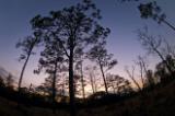
A short walk along the ABRP’s Garden of Eden trail quickly shows any observant hiker what ecosystems are all about. The trailhead begins in dry, sandy, upland soil dominated by soaring longleaf pine and an understory of wiregrass and turkey oak. This is a fire-adapted community of plants, with fire supporting the stately pine as the height-dominant species, while keeping the turkey oak short, stimulating the wire grass, and keeping out plants that don’t belong in this ecosystem.
Even if you knew nothing about ecology, you can see there must be a relationship between the land and the trees because of the contrast you see as soon as you head down a trail to one of the ravines. The ravines suddenly lose the pine and oak and become a place of hardwoods that reminds one of more northern locations in the Appalachian Mountains. This happens so fast and the terrain changes so dramatically that you have to notice something is going on here.
These are no ordinary ravines from rain runoff. If you know a gully from traditional erosion, you know what happens. Rain floods over a field probing for a weak spot in the ground. Once that spot is found, the water rushes in, cutting a gash in the soil, enlarging it to a ravine over time.
At the Preserve, the ravines come from a totally different process. Water sinks through the dry sandy soil of the uplands where the longleaf pine and wire grass grow, but then hits limestone rock a ways below the surface. It then runs along the rock until it finds an opening in a hillside. At first, this was the banks along the Apalachicola River. The water found its way to the river, but started washing out the sand above it as it went. Gradually, a small stream developed and the head of the stream went farther and farther away from the river, creating very steep ravines. These are called steephead ravines because of the steep hillsides that come from a small seepage spring at the head and make the stream.
As soon as you enter a steephead ravine, you immediately feel in a different place. It is cooler and moister than the dry longleaf pine uplands, yet they may only be 100 yards apart. Here you find beech trees, magnolia, along with shrubs like Florida anise and sparkleberry. No fires get into the woods here because the plants and conditions do not support it. But the conditions do support a much denser canopy of leaves, which keeps the area even cooler and moister.
That is ecology in action. You don’t need to be a scientist to understand that environments are different and conditions in those environments affect the plants that live in these places. You immediately see differences in ecosystems as you walk from one place to another. You also feel it as mosquitoes attack you in the ravines, but are far less common in the dry uplands.
Global warming is all the rage today, but it can be hard to understand in terms of what it might actually do to a location. Walk the trail in the Apalachicola Ravines and Bluffs Preserve and you quickly gain a sense of what it means to change environmental conditions and how that might affect a landscape.
Writer, photographer, and speaker Rob Sheppard edited Outdoor Photographer for many years until recently and continues there as editor-at-large. A trained naturalist and author of more than 20 photo books, he is also former editor of PC Photo, and his work has been published in magazines ranging from National Geographic to The Farmer.
Go to the Map

Use the interactive map to zoom smoothly from a national view to state and local perspectives anywhere across the country.
Go Straight to Your State
Learn about conservation and open space in your state.
Contribute to LandScope

Want to join, work with us or simply find out more? Learn how you can get involved.
