

 © Pete Saloutos/Panoramic Images (Washington Title Image Large)
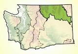
Okanogan: People in the Ecoregion
Numerous Interior Salish tribes have made their homes in the Okanogan for millennia. Okanogan tribes wintered in permanent camps, living in longhouses made of tules (hardstem bulrush), bark, and hides. They harvested scores of types of berries, nuts, and roots.
Traveling seasonally, they hunted bear, deer, and other game. Tribes gathered at Kettle Falls on the Columbia to fish for salmon and to trade.
The mapmaker and fur trader David Thompson visited Kettle Falls in 1811, and the Hudson Bay Company established a trading post there in 1825.
Gold was discovered near Republic in the 1890s and a mining boom followed. The timber industry developed in the ecoregion about the same time. Homesteading began in earnest at the beginning of the twentieth century.
Land use varies in the Okanogan and depends largely on elevation. The high country is devoted to mostly recreational uses, though mineral exploration and development continue. At mid-elevations, logging and grazing occur in the Okanogan’s pine forests.
In the valleys, milder temperatures support ranching and agriculture. Hay, alfalfa, and tree fruit (apples, apricots, cherries, peaches, pears) are primary products.
The sunny climate and ample recreation opportunities make the Okanogan ecoregion popular for vacation homes and tourists. The Grand Coulee Dam and miles of boating opportunities along Franklin D. Roosevelt Lake draw people to the ecoregion.
Roughly two-thirds of the Okanogan ecoregion is in state, federal, or tribal ownership. The Colville and Spokane tribes own 2,100 square miles and the state has 835 square miles.
The Forest Service controls 3,100 square miles (just under a third of the total). In addition to the federally protected 529,000-acre Pasayten Wilderness Area, there are more than a dozen designated Natural Areas in the Okanogan.
For details of this ecoregion within Washington, click a subheading in the left column.
View the more general description of this ecoregion in North America
Go to the Map

Use the interactive map to zoom smoothly from a national view to state and local perspectives anywhere across the country.