

 © Pete Saloutos/Panoramic Images (Washington Title Image Large)
Wind Power Resource Estimates
Overview
This data set shows the annual average wind resource potential for Washington State at a height of 50 meters, providing information on the wind resource development potential within the state.
Data Layer Description
Source
What this data layer represents
Data shows areas of wind energy potential and possible capacity for wind turbines or wind farm development.
Location
Data encompasses the state of Washington. The spatial data is not suitable for micro-siting projects. Data was generated from 400m resolution raster data sets.
Description
This data set shows the annual average wind resource potential for Washington State at a height of 50 meters, providing information on the wind resource development potential within the state.
How to get the data layer
Data can be downloaded from the National Renewable Energy Laboratory (NREL) GIS website
How you might make use of this data layer
The data can be used for awareness of the potential of wind resource development.
How to get more information
Vist the U.S. Dept. of Energy, Energy Efficiency and Renewable Energy website
Sample Map
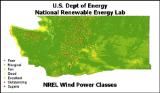
© U.S. Dept of Energy - NREL Wind Power Resource Estimates Sample Map

