 © Bruce McNitt/Panoramic Images (Virginia)
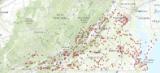
Virginia Birding and Wildlife Trail Sites
Overview
This layer shows the starting points of the trails that make up the state-wide Virginia Birding and Wildlife Trail.
Data Layer Description
Source
Virginia Department of Conservation and Recreation - Division of Natural Heritage
What this data layer represents
The Trail uses existing highways, scenic byways and historic trails to link birding and wildlife watching sites throughout Virginia.
Location
Virginia
Description
The Virginia Birding and Wildlife Trail is the first statewide program of its kind in the United States. Three phases of this driving trail link wildlife viewing sites throughout the state that have a wide variety of outdoor recreation opportunities.
The Trail uses existing highways, scenic byways and historic trails to link birding and wildlife watching sites throughout Virginia. The Trail improves visitors’ experiences as they drive along existing roadways, stop at a variety of different sites to observe flora and fauna, and stop at parks and other wildlife viewing areas to hike and explore.
The Virginia Birding and Wildlife Trail is a statewide project coordinated by VDGIF as part of its mission to “manage Virginia’s wildlife…to serve the needs of the Commonwealth, and to provide opportunity for all to enjoy wildlife… and outdoor recreation.” Like the Great Texas Coastal Birding Trail, the Virginia Trail is a key, long-term tool involving Virginians and visitors in wildlife habitat conservation and restoration. As a growing number of nature tourists spend their time and money along the Trail, communities want to invest in the natural resources that are attracting tourism dollars. By providing easy and exciting access to birds and other species, the Birding and Wildlife Trail increases the number of people involved in wildlife watching. A study conducted by the Conservation Management Institute at Virginia Tech in 2007 estimated that over 640,000 people per year visit the Trail and spent over $8.6 Million dollars annually.
Currently the Trail consists of 680 sites developed into 65 separate loops. Loops are designed, in most cases, to take 3-4 days to complete. Directions are provided from site to site and pass through many of the local communities. This keeps people in the local communities to spend money on gas, food, lodging and shopping.
How to get the data layer
Visit the VA-DCR's Conservation Lands Data Downloads page.
How to get more information
To purchase a copy of the Virginia Birding and Wildlife Statewide Trail Guide you can call 1-866-74-VABWT (748-2298).
For more information on the Trail, visit Virginia Department of Game and Inland Fisheries
Sample Map