 © Bruce McNitt/Panoramic Images (Virginia)
Virginia State Wildlife Action Plan - Mapped Habitats
Overview
The Wildlife Action Plan Mapped Habitats layer shows locations of confirmed and/or potential habitat of Tier 1 and Tier II Specie of Greatest Conservation Need created for the Virginia Wildlife Action Plan (WAP).
Data Layer Description
Source

Virginia Department of Game and Inland Fisheries, Wildlife Diversity Division
What this data layer represents
Created as part of the Virginia Wildlife Action Plan, this layer is intended to highlight wildlife habitat conservation opportunities in Virginia.
Location
Commonwealth of Virginia
Map scale: Landscape Scale (1:24,000)
Description
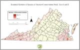
These data identify important areas to be conserved based on the Virginia Wildlife Action Plan. The Virginia Wildlife Action Plan identified 924 wildlife species as “species of greatest conservation need.”
These data show the number of Tier 1, 2, or listed species with mapped potential or confirmed essential habitat across Virginia,combining the mapped habitats from 149 terrestrial species and 98 aquatic species. Of the 358 species in these Tiers, habitat was mapped for 247 species.
These habitats were summarized to show areas of conservation opportunity. This dataset is intended to highlight wildlife habitat conservation opportunities in Virginia. All areas with the potential to support a tiered species species are important, however areas that may support multiple species represent areas of greater conservation impact.
These species were divided into 4 Tiers of Imperilment:
- Tier I – Critical Conservation Need
- Tier II – Very High Conservation Need
- Tier III – High Conservation Need
- Tier IV – Moderate Conservation Need
This map shows the compiled essential habitat for species within Tier I, the most imperiled wildlife species. The result is a combination of mapped habitat from 86 species (53 terrestrial and 33 aquatic species). Habitat for some of the species was not mappable. Of the 86 species with mapped potential or known habitat locations, a summary was developed to display areas of conservation opportunity. This raster dataset shows this compilation of all identified essential habitats.
How to get the data layer
Kendell Ryan
Virginia Department of Game and Inland Fisheries
4010 W. Broad St
Richmond, VA 23230
(804) 367-0068
How you might make use of this data layer
This dataset is intended to highlight wildlife habitat conservation opportunities in Virginia. Any area with the potential to support a single Tiered species is important, however areas that may support multiple species represent the potential for greater conservation impact.
These spatial data show the density of Tier I species habitat across Virginia. Protecting these locations, especially locations that support multiple species, from various threats is critical to wildlife conservation. These data may be used to prioritize land conservation or to show patterns of where wildlife conservation actions are needed most.
How to get more information
Sample Map