 © Bruce McNitt/Panoramic Images (Virginia)
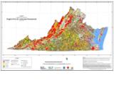
Virginia ConservationVision - Natural Landscape Assessment, Ecological Cores
Overview
The Virginia Natural Landscape Assessment (VaNLA) identifies unfragmented natural habitats called Ecological Cores, or large patches of natural land cover with at least 100 acres of unfragmented, interior conditions. Cores consist mainly of upland forests and forested wetlands statewide, but also marshes, beaches, and dunes in the coastal plain. Ecological Cores provide habitat for a wide range of species, from those dependent upon interior forests to habitat generalists, as well as species that utilize marsh, dune, and beach habitats. An ecological integrity score was calculated for all cores based on various metrics of biodiversity, ecological function and landscape condition. Ecological Integrity of all cores range from 1-Outstanding to 5-General.
Data Layer Description
Source

Virginia Department of Conservation and Recreation, Division of Natural Heritage
What this data layer represents
This layer represents identifies lands to preserve and manage to help assure that ecological function and species population changes might vary spatially and temporally, and as needed in the face of rapidly changing landuse and climate. This layer also provides a starting point for local planning efforts in Virginia, for conservation efforts, land management plans, land use planning and climate change adaptation.
Location
Commonwealth of Virginia plus a 20-mile buffer
Map scale: Landscape Scale (1:50,000 or coarser)
Description
The Virginia Natural Landscape Assessment (VaNLA), a component of the Virginia ConservationVision, is a landscape-scale GIS analysis for identifying, prioritizing, and linking natural habitats in Virginia. Using land cover data derived from satellite imagery, the VaNLA identifies unfragmented natural habitats called Ecological Cores, large patches of natural land cover (mainly upland forests and forested wetlands statewide, but also marshes, beaches, and dunes in the coastal plain) with at least 100 acres of interior conditions. Large, medium, and small Ecological Cores have been identified, along with a smaller feature type called Habitat Fragments that may be important in the more urban localities. Ecological Cores provide habitat for a wide range of species, from those dependent upon interior forests to habitat generalist, as well as species that utilize marsh, dune, and beach habitats. Ecological Cores also provide benefits in terms of open space, recreation, water quality (including drinking water protection), and carbon sequestration, along with the associated economic benefits of these functions.
The VaNLA was initiated in the Virginia Coastal Zone via funding from the Virginia Coastal Zone Management Program (NOAA Grant # NA05NOS4191180, Task 92.05 and NOAA Grant # NA03NO54190104, Task 95.01), and completed via funding from the Virginia Land Conservation Foundation.
How to get the data layer
http://www.dcr.virginia.gov/natural_heritage/vclna.shtml
How you might make use of this data layer
Maintaining vital natural landscapes is essential for basic ecosystem services such as cleaning our air and filtering our water. Natural lands also harbor thousands of species of animals and plants and contain libraries of genetic information from which we derive new foods, materials, and medicinal compounds. These parts of the landscape also provide us with recreational opportunities and open space resources. But these qualities are represented differently across the Ecological Cores of the natural landscape. To assess their unique values, each Ecological Core has been assigning an ECOLOGICAL INTEGRITY score that rates the relative contribution of that area to the values above. In general, larger, more biologically diverse areas are given higher scores. Scores are enhanced for Ecological Cores that are components of larger complexes of natural lands and for those that contribute to water quality enhancement.
The Virginia Natural Landscape Assessment (VaNLA) can help guide effective conservation by producing data layers showing some of the most ecologically significant areas and important landscape connections in Virginia, thus providing governments and conservation partners with tools to identify resource protection areas. At the local level, these data also can help planners manage growth to keep new development out of the most sensitive areas.
How to get more information
http://www.dcr.virginia.gov/natural_heritage/vclna.shtml
Access and use constraints
 Attribution (BY)
None
Credits
Bulluck, J. F., J. M. Ciminelli, and J. T. Weber, 2007. Natural Landscape Assessment
and Green Infrastructure – Completion and Distribution: Final Report. Natural Heritage
Technical Report #07-17. Virginia Department of Conservation and Recreation, Division
of Natural Heritage. Richmond, Virginia.
Sample Map