 © Bruce McNitt/Panoramic Images (Virginia)
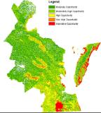
Virginia Priority Wildlife Diversity Conservation Areas
Overview
The Priority Wildlife Diversity Conservation Areas (PWDCA) dataset identifies areas important to conservation of nongame wildlife, according to DGIF biologists, Virginia's Wildlife Action Plan, and other sources.
Data Layer Description
Source
Virginia Department of Game and Inland Fisheries
What this data layer represents
The PWDCA highlights areas due to the presence of unfragmented habitat, wetlands, identified habitat for rare species, and/or special wildlife features such as waterbird colonies, designated important bird areas, or anadromous fish use areas. Areas are also included in the PWDCA if they border these features, providing a minimum protective buffer.
Location
Coastal Zone counties of the Commonwealth of Virginia
1:24,000 to 1:100,000
Description
The Priority Wildlife Diversity Conservation Areas (PWDCA) dataset was created by the Virginia Department of Game and Inland Fisheries (DGIF) to identify areas important to conservation of nongame wildlife, based on recommendations from DGIF biologists, Virginia’s Wildlife Action Plan, and other sources. This is part of a larger effort to map Priority Conservation Areas in the coastal zone of Virginia through a partnership between DGIF, Department of Conservation and Recreation – Natural Heritage, and Virginia Commonwealth University’s Center for Environmental Studies.
The PWDCA was developed via funding from the Virginia Coastal Zone Management Program (NOAA grant FY08 NAO8NOS4190466, Task 11.02).
How to get the data layer
The PWDCA is a compilation of existing datasets ranked by agency biologists. Because these source datasets, as well as our knowledge about wildlife resources are dynamic, we strongly recommend you contact DGIF for specific recommendations on your area of interest. It is also recommended that you request updates of the PWDCA dataset at least once every 6 months. The PWDCA is available for download at: http://www.dgif.virginia.gov/gis/gis-data.asp
For further information, please contact:
Shirl Dressler in the Wildlife Diversity Division
804-367-6913
or at: shirl.dressler@dgif.virginia.gov
How you might make use of this data layer
The PWDCA is a generalized subjective map intended to guide initial conservation planning or green infrastructure efforts. It does not replace the need for on-the-ground surveys or consultations with biologists, land managers, and planners. This map does not constitute official legal or technical advice. The PWDCA highlights areas due to the presence of unfragmented habitat, wetlands, identified habitat for rare species, and/or special wildlife features such as waterbird colonies, designated important bird areas, or anadromous fish use areas. Areas are also included in the PWDCA if they border these features, providing a minimum protective buffer. The PWDCA has values from 1-5, with 5 being the highest priority. Again, all areas within the PWDCA are important. The 1-5 values are subjective rankings based on expert opinions. It is recommended that priority be given to sites with the highest PWDCA value in consultation with a wildlife biologist using contact information below. Please also consider protection and management of entire watersheds, as impacts to headwaters areas have cumulative affects on downstream priority features such as rivers and wetlands.How to get more information
Contact:
Shirl Dressler
Wildlife Diversity Division
804-367-6913
or at: shirl.dressler@dgif.virginia.gov
Sample Map