 © Bruce McNitt/Panoramic Images (Virginia)
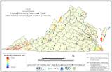
Virginia Biodiversity Assessment
Overview
The Virginia Biodiversity Assessment (VBA) displays lands with known and predicted biodiversity, based on data and information from the Virginia Department of Conservation and Recreation-Division of Natural Heritage and the Virginia Dept. of Game and Inland Fisheries.
Data Layer Description
Source
Virginia Department of Conservation and Recreation, Division of Natural Heritage
What this data layer represents
This layer is a summary of known and predicted biodiversity ranked by biodiversity significance.
Location
Commonwealth of Virginia
Scale: 1:24,000
Description
The Virginia Natural Heritage Program (VNHP) in the Department of Conservation and Recreation has developed various GIS planning tools to facilitate land conservation with the ultimate goal of protecting biodiversity. One of these tools, the conservation sites layer, maps habitats of known populations of rare plants and animals, and locations of exemplary natural communities, providing each site with a biodiversity significance ranking. Virginia Natural Heritage also developed a Natural Landscape Assessment (VaNLA) which identifies the remaining intact habitat cores in throughout Virginia, ranks them based on Ecological Integrity and identifies “corridors” that would provide landscape level connectivity for these lands. Virginia’s Dept. of Game and Inland Fisheries (DGIF) maintains several predictive range maps for State and Federal Threatened and Endangered Species, as well as their Teir 1 and Teir 2 Species of Greatest Conservation Need.
The VBA summarizes lands in Virginia with known and predicted biodiversity values based on these datasets, so that planning efforts might comprehensively consider values identified by these agencies’ data and information. The VBA ranks the most important VaNLA cores and corridors based on the biodiversity rankings of Natural Heritage Conservation Sites within them, so that cores are displayed according to the biodiversity they are known to harbor. Likewise, DGIF predicted range maps, representing essential habitats for Species of Greatest Conservation Need, are also ranked by their biodiversity values. The final output map displays these lands on a 5-level classification from high to moderate biodiversity significance. The VBA was funded by the Virginia Coastal Zone Management Program (NOAA Grant # NA07NOS4190178, Task 93.03), the Virginia Land Conservation Foundation, and NatureServe.
How to get the data layer
The layer is available for viewing on Landscope Virginia (http://www.landscope.org/virginia/) and Coastal GEMS (http://www.deq.virginia.gov/coastal/coastalgems.html).
The VBA can be obtained via contacting the Virginia Natural Heritage Program http://www.dcr.virginia.gov/dnh.
How you might make use of this data layer
These maps are not appropriate for project specific environmental review or for on-site surveys required for environmental assessment of specific project areas. These tools are altogether inadequate for assessing impacts of human-induced changes to habitat on associated species. VBA products will be appropriate for use at local and state levels for summarizing conservation values and for land use planning efforts.
How to get more information
More information on the VBA is available from the Virginia Natural Heritage Program http://www.dcr.virginia.gov/dnh.
Sample Map