

 © Louis Vest (LandScope Texas Banner)
Public Boat Ramps
Overview
TPWD Game Wardens using Garmin GPS units collected coordinate point data at public access boat ramps in their jurisdiction.
Data Layer Description
Source

Texas Parks and Wildlife Department (TPWD)
Location
Texas
Description
This data, updated in 2011, represents sites where public boat ramp access is available. This feature class was created from points collected by TPWD employees locating public access boat ramps throughout Texas.
How to get the data layer
Contact the TPWD GIS Lab Manager, Kim Ludeke.
How you might make use of this data layer
The public can use this dataset to locate boat ramp access within the inland and coastal waters of Texas.
How to get more information
Visit the “Where to Boat” website provided by TPWD.
Access and use constraints
Attribution Non-Commercial (BY-NC) This license lets others remix, tweak, and build upon our work non-commercially, and although their new works must also acknowledge us and be non-commercial, they do not have to license their derivative works on the same terms. (http://creativecommons.Org/licenses/by-nc/3.0/)
Credits
Texas Parks and Wildlife Department. 2011.
Sample Map
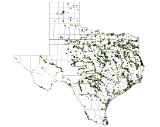
© Texas Parks and Wildlife Department Public Boat Ramps

