

 © Louis Vest (LandScope Texas Banner)
Priority Protection Habitat Areas
Overview
Priority coastal habitat areas to be protected during oil or hazardous material spills on the Texas coast.
Data Layer Description
Source
Texas General Land Office (TGLO)
Location
Texas Gulf Coast
Description
This dataset was created in 1992-1993 and identifies polygonal areas adjacent to coastal bays and the Gulf of Mexico containing sensitive coastal habitats or species to be protected from oil spill contamination or response activities. Defined and digitized by Texas General Land Office personnel and based on consultation with representatives of Texas Parks and Wildlife Department and other public agencies, academic institutions, and private groups and citizens.
How to get the data layer
This data can be found on the TGLO's GIS Lab's website.
How you might make use of this data layer
This dataset identifies specific environments in need of protection from oil spill contamination and other hazardous activities.
How to get more information
More information about polygons is contained in supplementary hardcopy documents or text files at General Land Office. Also, view TGLO’s Online Map Viewer.
Sample Map
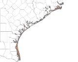
© Texas General Land Office Priority Protection Habitat Areas

