

 © Louis Vest (LandScope Texas Banner)
Environmental Sensitivity Index Shoreline
Overview
This dataset displays the shoreline of Texas with Environmental Sensitivity Index classification, which are shoreline habitats that are sensitive to oil contamination and removal. Classification conducted by the University of Texas Bureau of Economic Geology.
Data Layer Description
Source

Texas General Land Office (TGLO)
Location
Texas
Description
Updated 2008 data of shoreline habitat identified based on sensitivity to oil contamination and removal. These data are not intended to precisely delineate the average natural shoreline (land/water interface) and may not be used to delineate boundaries between public and private land. Shoreline arc features were extracted from the U.S. Fish and Wildlife Service 1992 National Wetland Inventory digital data files by TGLO. The Environmental Sensitivity Index code values were assigned by coastal geologists within the University of Texas Bureau of Economic Geology to represent sensitivity to oil spills and ease of cleanup. This dataset is not to be used for navigational purposes or for delineating boundaries between public and private land. Below are descriptions of shoreline types according to the Environmental Sensitivity Index:
- Value 1: walls and other solid structures (least sensitive shoreline type)
- Value 2A: scarps/steep slopes in clay
- Value 2B: wave-cut clay platforms
- Value 3A: fine-grained sand beaches
- Value 3B: scarps/steep slopes in sand
- Value 4: coarse-grained sand beaches
- Value 5: mixed sand and gravel or shell beaches
- Value 6A: gravel or shell beaches
- Value 6B: exposed riprap structures
- Value 7: exposed tidal flats
- Value 8A: sheltered riprap structures
- Value 8C: sheltered scarps
- Value 8D: sheltered rocky or karst shores (added by William White to describe karst outcrops in Baffin Bay, TX)
- Value 9: sheltered tidal flats
- Value 10A: salt and brackish marshes
- Value 10B: freshwater marshes (herbaceous vegetation)
- Value 10C: freshwater swamps (predominantly woody vegetation)
- Value 10D: mangroves or woody vegetation in salt water
How to get the data layer
This data can be found on the TGLO's GIS Lab's website.
How you might make use of this data layer
This environmentally conscious data layer provides information for potential hazards in the Gulf Coast of Texas and can be used as a means of assessing these hazards in the future.
How to get more information
The TGLO’s Online Map Viewer.
Credits
Texas General Land Office. 2008.
Sample Map
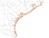
© Texas General Land Office Environmental Sensitivity Index Shoreline

