Pennsylvania Landscape Conservation Areas
Overview
The dataset was developed as part of the County Natural Heritage Inventories. The results of the County Natural Heritage Inventories are intended for use in landuse planning by state and local government officials, environmental and development consultants, and developers. The Inventories are also intended to be a resource to inform educators, conservation organizations, and other interested citizens regarding local rare species, natural communities and other natural resources.
Data Layer Description
Source

Pennsylvania Natural Heritage Program, Western Pennsylvania Conservancy
What this data layer represents
Landscape Conservation Area refers to large contiguous areas that are important because of their size, open space, habitats and/or inclusion of one or more core habitats for species of concern. These large regions in relatively natural condition can be viewed as regional assets; they improve quality of life by providing a landscape imbued with a sense of beauty and wilderness, they provide a sustainable economic base, and their high ecological integrity offers unique capacity to support biodiversity and human health. Whole suites of species as well as general ecological and environmental processes can be offered protection by focusing conservation efforts on large expanses of quality habitats of all types. Planning and stewardship efforts can preserve these functions of the landscape by limiting the overall amount of land converted to other uses, thereby minimizing fragmentation of these areas.
Location
a) Pennsylvania
b) 1:24,000
Description
This layer contains the Natural Heritage Inventory Landscape Conservation Areas (LCA) identified through the County Natural Heritage Inventory project of the Pennsylvania Natural Heritage Program. County Natural Heritage Inventories focus on areas that are the best examples of ecological resources in a county. Although agricultural lands and open space may be included as part of inventory areas, the emphasis for the designation and delineation of the areas are the ecological values present. Important selection criteria for Natural Heritage Areas are the existence of habitat for plants and animals of special concern, the existence of uncommon or especially important natural communities, and the size and landscape context of a site containing good quality natural features. Large areas and areas that are minimally disturbed by development provide the backbone that links habitats and allows plants and animals to shift and move across sizable portions of the landscape. LCAs are intended to identify large contiguous area that are important because of their size, open space, habitats, and/or inclusion of one or more cores habitats. of Natural Heritage Areas. Although an LCA includes a variety of land uses, it typically has not been heavily disturbed and thus retains much of its natural character. Polygons are based on aerial photo interpretation, field surveys, and existing PNHP data and were delineated by the ecologists on-screen using ArcView (ESRI, Inc., Version 3.3, 8x, and 9x) with the 1:24,000 scale USGS Digital Raster Graphics and/or Digital Aerial Photography images as a background. For each LCA polygon, the attribute table contains fields indicating the Site Name and Significance. See individual CNHI reports for further information on methodology, site descriptions, and species or communities found at each site.
These data represent information that can be used to guide County Planning and Conservation. Use of the information in the report does not replace Pennsylvania Natural Diversity Inventory (PNDI) Environmental Reviews which may be required for specific projects. By acceptance of this data, the user agrees to include a copy of this metadata record, including the liability disclaimer, whenever the user transmits or provides the GIS Data (or any portion of it) to another user.
How to get the data layer
The CNHI reports are available for download at http://www.naturalheritage.state.pa.us/CNHI.aspx
Links to a GIS map service of the CNHI dataset are available at http://www.naturalheritage.state.pa.us/cnhi/cnhi.htm
To obtain a copy of CNHI dataset contact:
Christopher Tracey
Conservation Planning Coordinator
Western Pennsylvania Conservancy
800 Waterfront Drive
Pittsburgh, PA 15222-4718
ctracey@paconserve.org
How you might make use of this data layer
This dataset is intended as a tool in planning to avoid the accidental destruction of habitats supporting species of concern at both the county and municipal levels. CNHIs have been incorporated into comprehensive plans, consulted to plan development projects, and utilized by conservation organizations to prioritize their work. Additionally, these studies have been used to help in the development of recreational amenities, promotion of tourism industries and assistance in community development.
How to get more information
The CNHI reports contain further information on methodology, site descriptions, and species or communities found at each site. The reports are available for download at the Pennsylvania Natural Heritage Program website.
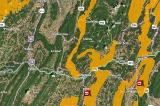
Sample Map