 © Steve Vaughn/Panoramic Images (Florida Title Image Large)
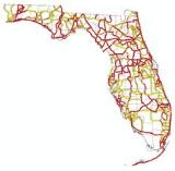
Florida Multi-use Trail Opportunities
Overview
A multi-use trail is one where two or more user groups (equestrian, hiking, off-road biking) can use the trail simultaneously. The areas shown in this layer are intended to identify opportunity corridors of statewide and regional significance. The trail priorities contained in this dataset were approved by the Florida Greenways and Trails Council in September 2008.
Data Layer Description
Source

University of Florida GeoPlan Center and Florida Office of Greenways and Trails
What this data layer represents
Prioritized multi-use trail opportunities from the Office of Greenways and Trails Prioritization Project.
Location
Florida
Description
A multi-use trail is one where two or more user groups (equestrian, hiking, off-road biking) can use the trail simultaneously. Multi-use trails can be either paved or unpaved. The areas shown in this layer are intended to identify opportunity corridors of statewide and regional significance. These corridors are 4 kilometers (approx. 2.5 miles) wide to reflect the variability of actual trail location after planning and design is completed. The trail priorities contained in this dataset were approved by the Florida Greenways and Trails Council in September 2008. This GIS layer was created by the Office of Greenways of Trails and the UF GeoPlan Center, to support the Florida Statewide Greenways & Trails System.
How to get the data layer
How you might make use of this data layer
The Multi-use Recreational Trail Opportunities is a data layer that guides trail planning and acquisition by the Office of Greenways and Trails. It informs the recreational priorities of the Florida Forever conservation land acquisition program and is part of the Florida Forever Conservation Needs Assessment.
How to get more information
Sample Map