 © Steve Vaughn/Panoramic Images (Florida Title Image Large)
Florida Ecological Greenways Network
Overview
The Florida Ecological Greenways Network model was created to delineate the ecological component of a Statewide Greenways System plan developed by the DEP Office of Greenways and Trails, under guidance from the Florida Greenways Coordinating Council and the Florida Greenways and Trails Council.
Data Layer Description
Source

University of Florida GeoPlan Center and Florida Office of Greenways and Trails
What this data layer represents
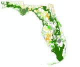
This data layer is intended to represent a statewide network of ecological hubs and linkages designed to maintain large landscape-scale ecological functions throughout the state. Ranking is highest for Strategic Linkages. Ranking outside Strategic Linkages is from 1 to 6, with 1 representing the highest priority areas and 6 representing the least.
Location
Florida
Description
The Florida Ecological Greenways Network model was created to delineate the ecological component of a Statewide Greenways System plan developed by the DEP Office of Greenways and Trails, under guidance from the Florida Greenways Coordinating Council and the Florida Greenways and Trails Council. The model started with an aggregation of a variety of existing habitat models including FWC SHCAs, FWC Biodiversity Hotspots, FWC Priority Wetlands for Listed Species, FNAI Potential Natural Areas, FNAI Areas of Conservation Interest, existing and proposed conservation lands, and vegetation from FWC satellite imagery landcover.
These data were used to identify a series of hubs, or core areas, of large, landscape-scale ecological significance, and a network of corridors connecting the hubs into a statewide ecological greenways system. The entire model was updated in 2004 to include newly identified areas of ecological significance (including the FNAI Rare Species Habitat Conservation Priorities and High Quality Watersheds models) and to remove recently developed areas.
Strategic Linkages 1= Parcels within Critical Linkages (Priority 1 below) that are critical for completing a corridor connection. Critical Linkages are defined as areas with very high or high ecological significance while also having areas threatened by development.
Strategic Linkages 2= Parcels within Priority 2 ( below) that are critical for completing a corridor connection. Critical parcels 1 and 2 together would complete a statewide reserve network.
Priority 1 (Critical Linkages) = Remaining areas of Critical Linkages not covered by Critical Parcels 1. Critical Linkages are defined as areas with very high or high ecological significance while also having critical areas threatened by development.
Priority 2 = Remaining areas of Priority 2 greenways not covered by Critical Parcels 2.
Priority 3 = Priority 3 ecological greenway corridors.
Priority 4 = Priority 4 ecological greenway corridors.
Priority 5 = Priority 5 ecological greenway corridors.
Priority 6 = Priority 6 ecological greenway corridors. Priority 6 includes existing conservation lands.
For Priorities 2-6, the ecological greenways corridors are prioritized based on:
1) potential importance for maintaining or restoring populations of wide-ranging species (e.g. Florida black bear and Florida panther);
2) importance for maintaining statewide, connected reserve network from south Florida through the panhandle;
3) other important landscape linkages that provide additional opportunities to maintain statewide connectivity especially in support of higher priority linkages;
4) provide important riparian corridors within Florida and to other states and
5) other regionally significant opportunities to protect large intact landscapes.
How to get the data layer
Florida Department of Environmental Protection Geospatial Open Data
How you might make use of this data layer
The Ecological Greenways model guides Office of Greenways and Trails land acquisition and conservation efforts, and promotes public awareness of the need for and benefits of a statewide greenways network. It is also used as the primary data layer to inform the Florida Forever conservation land acquisition program regarding the location of the most important conservation corridors and large, intact landscapes in the state.
Presence of this data layer on a site indicates that the location is within a central hub of landscape-scale ecological significance, or within a landscape corridor connecting two or more hubs. The higher the priority, the more significant the hub or corridor is to the overall statewide ecological greenways network.
If this data layer is absent, the location is not considered to be of large landscape-scale ecological significance, or within a potential connector of major ecological hubs. The location may still feature important habitat for rare species or other natural resources, or be part of an important regional or local conservation corridor. A systematic field survey by qualified professionals would be required to determine the presence or absence of rare species or other resources on the site.
How to get more information
Greenways and Trails Network Homepage
Sample Map