Delaware Ecological Network
Overview
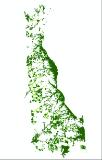
The Delaware Ecological Network (DEN) is a statewide conservation network developed from GIS and field-collected data. The DEN, based on principles of landscape ecology and conservation biology, provides a consistent framework to help identify and prioritize areas for natural resource protection. The DEN is composed of the following elements: core areas, which contain relatively intact natural ecosystems, and provide high-quality habitat for native plants and animals; hubs, which are slightly fragmented aggregations of core areas, plus contiguous natural cover; and corridors, which link core areas together, allowing wildlife movement and seed and pollen transfer between them. Core areas were validated using independent field data, and verified using aerial photos.
Data Layer Description
Source
The Conservation Fund
Location
Delaware
Scale: data compiled at multiple scales
Description
The Delaware Ecological Network (DEN) is a statewide conservation network developed from GIS and field-collected data. The DEN, based on principles of landscape ecology and conservation biology, provides a consistent framework to help identify and prioritize areas for natural resource protection. The DEN is composed of the following elements: core areas, which contain relatively intact natural ecosystems, and provide high-quality habitat for native plants and animals; hubs, which are slightly fragmented aggregations of core areas, plus contiguous natural cover; and corridors, which link core areas together, allowing wildlife movement and seed and pollen transfer between them. Core areas were validated using independent field data, and verified using aerial photos. Core areas and hubs were ranked by ecoregion according to their ecological importance, critical linkages were identified, and a top-priority network was identified within the overall network. Next, relative protection of core areas, hubs and corridors was evaluated; the natural resource features captured by the network were tabulated; and potential focus areas were examined. The DEN is relatively efficient at capturing the state’s important ecological features, covering 30% of the state’s land, but including most of its forests, wetlands, streams, and rare species; especially natural areas of high quality. The first application of the DEN was in Kent County, Delaware, where it was combined with parcel data and preferences from a leadership forum to develop a decision support tool, to allow conservation practitioners to both proactively identify new opportunities at the parcel level, and evaluate project requests as they arise.
How to get the data layer
Contact Ted Weber at the Conservation Fund
or download the layer here.
How you might make use of this data layer
This layer is designed to focus protection efforts in Delaware.
How to get more information
View links to metadata for individual layers here.
Sample Map